
Jet Stream
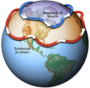
By Michael FaginMt. Everest WeatherJet Stream. The subtropical jet stream, the Himalayan Plateau and Mt. Everest. The strongest large-scale wind system, the subtropical jet stream is the steadiest wind belt in the upper troposphere. The weather feature is only semi-permanent – big weather such as cyclones and fronts can temporarily displace it. When shifted, it often splits into several smaller streams which can cause regionally unique effects.
It wasn’t until recently in history that scientists grew aware of the invisible atmospheric circulations, much less how much they contribute to the weather. The first known hypothesizes of the existence of jet streams were brainchildren of the mid-19th Century. The first confirmation of their existence came from bomber pilots when they encountered one mid-flight during WWII.
Winds in the subtropical jet stream reside above subtropical high pressure, which causes vertical movement, preventing the stream from extending to the surface. In the Northern Hemisphere, Earth’s major heat reservoir – the tall air mass (10-15 km) near the equator called the Hadley cell – is on the southern side of the subtropical jet stream. A sudden drop off in atmospheric height heading into the subtropics marks the location of the subtropical jet stream.
Jet Stream or The Subtropical Jet Stream,
It blows fastest over the western Pacific due to the higher elevations upstream along the Himalayan Plateau. Tall mountains like Mt. Everest and K2 cause orographic uplift. Ascending air is influenced by solar bombardment with tall ground levels, which conducts heat into the air that contacts the ground, which then convects downstream. The consistently high ground levels of the Plateau defeat the atmospheric angular momentum that would otherwise exist, which redirects winds and lowers their speeds; although individual storm cells with independent axis remain free to move independently. The concomitant return of angular momentum just east of the mountains leads to air quickening and reconverging.
Winds in the Himalayan subtropical jet stream start around the 400 mb (about 23,574 feet or 7187 meters) atmospheric layer and increase until around 150-200 mb, (about 38,662 feet or 11,787 meters) where they occasionally well exceed 200 mph but can continue to intensify if combined with certain weather features. The polar front jet tops that list. Extensive cloud cover manifests when the two streams converge within 300 nautical miles of each other. Cirrus clouds may be seen within 100 nautical miles farther. From a simple shift in the winds to monsoonal rains, a wide range of weather can be triggered by the movements of the subtropical jet stream.
The Seasonality of the Subtropical Jet Stream
The subtropical jet stream blows towards the east in the summer, and the main feature is a reduction in winds near Mt. Everest. However winds at lower levels blow from the south to southeast to bring the moisture in from the Bay of Bengal and resulting heavy rainfall at times. The summer is of course the monsoon season.
However in the winter months the subtropical jet stream is the can be found between 20-50 degrees latitude blowing at its strongest significantly stronger than in the summer. In fact at times in the winter and spring the Polar Front Jet combines with the Subtropical Jet Stream and this is when we can get the strongest winds from the west to northwest.
Climbers typically wait it out until spring arrives. Mid-May specifically is the perennial focus of climbing for Mt. Everest. Why the middle of May? This is when the Polar Front Jet Stream has moved to the north and the Subtropical Jet Stream winds decrease. This is also just before the monsoon season and heavy precipitation moves into the region.
However, is not a certainty from week to week. It’s best to first consult with an experienced Himalayan meteorologist to not only better plan a trip but also break down real-time details just before and during an ascent.
Article written by Meteorologist Geoff Linsley